
Edition #4
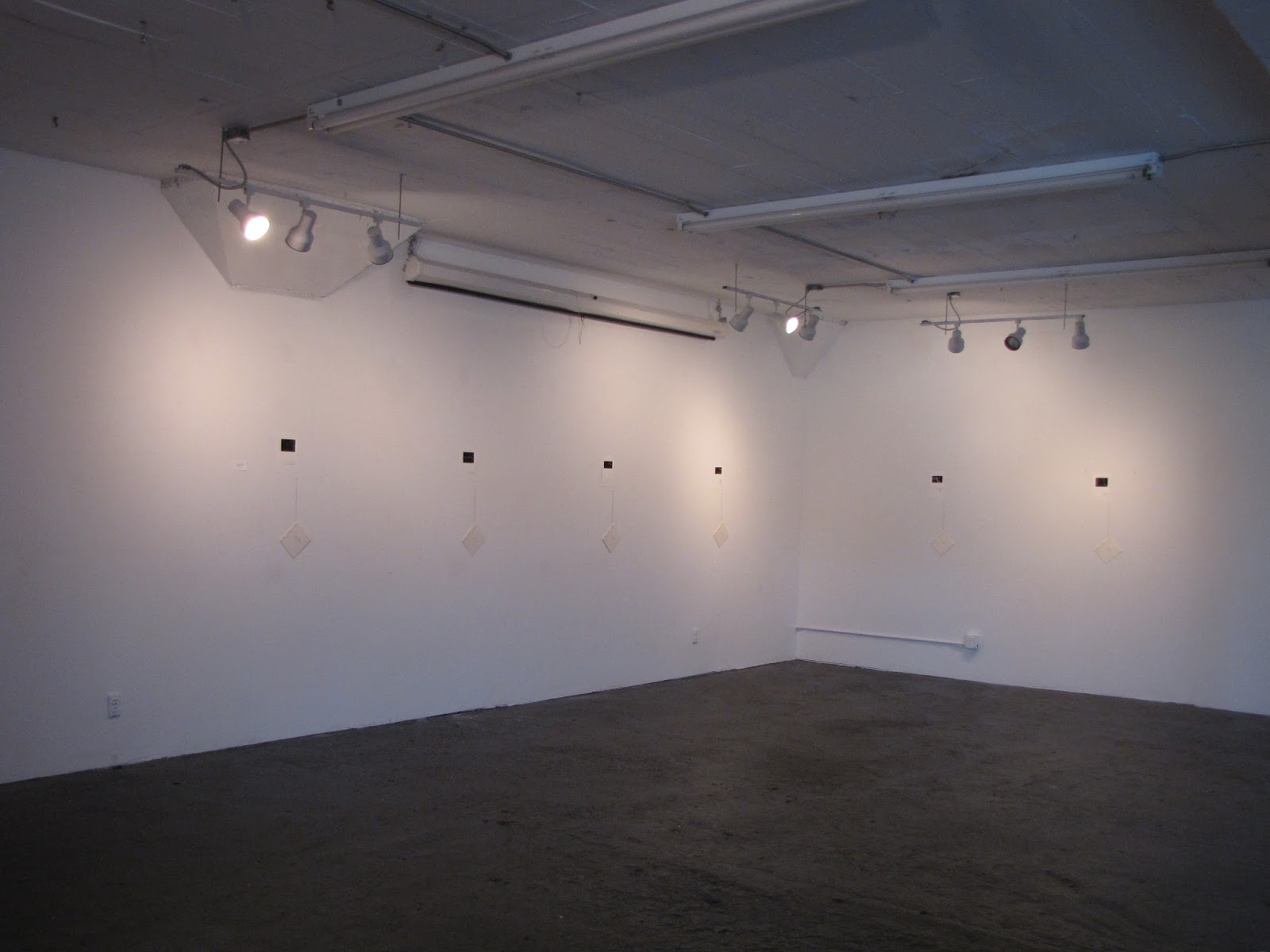
An exhibition and reading at Fresh Arts, with hand printed maps by Cathie Kayser, photos and other objects.


Excerpt from Chapter 7 of Disputed Territories: Ceuta and Milella
Across the Straits of Gibraltar in Ceuta and Melilla they build their Spanish homes on rocky African shores facing north with their backs to Morocco. The sign at the southern end of town says “Bienvenido a España.” The immigrants can't read Spanish. The traffic lights at the border flash green and red. Everyone knows what that means. Don't come in, Morocco. Ocupado.
The immigrants build ladders out of roughly hewn tree limbs and leave them leaning against the fence on the African side. Gibraltar's not so far away across the Mediterranean, a distance narrower than some stretches of the Amazon, narrower than the Volga. The way the Ceutans, Melillans, and refugees see it, the Mediterranean is just a Spanish river.
The immigrants build ladders out of roughly hewn tree limbs and leave them leaning against the fence on the African side. Gibraltar's not so far away across the Mediterranean, a distance narrower than some stretches of the Amazon, narrower than the Volga. The way the Ceutans, Melillans, and refugees see it, the Mediterranean is just a Spanish river.
Atlas Outtake #14: Small Ambitions
In the world's smallest state there are no births and the guards' wives travel over the border to bear their children on foreign territory.* All citizens of the world's smallest state are immigrants selected by members of the existing population, and their citizenship is revoked when they have fulfilled the duties for which they were selected. There is no space for embassies, for countrysides, forests, or rivers. The landscape is overwhelmingly stone and concrete. The borders are protected by men hired from the neighboring country; one border guard is hired for every six citizens. The border is marked by a white stripe painted on the ground. Only in one area—three meters by sixty—is there disputed territory, at the edge of the public square. The world's smallest state and its neighbor cannot agree on ownership of these three by sixty meters, but there is no incentive to fight about it, having fought over much larger pieces of land many times in the past: the world's smallest state is the vestige of a much larger state that used to contain more forests and rivers and women than its administrators could ever properly count, until the borders were pushed back by neighboring armies intent on creating the smallest state the world could ever imagine, a state within a state and city within a city whose territorial ambitions could be kept to a manageable three by sixty meters, so small there wasn't even room for a child to be born or any new territorial ambitions to be conceived.
* Only six percent of the population are women and most of these are not guards' wives: most of them will never bear children at all. Most of the citizens prefer the company of other men anyways.
* Only six percent of the population are women and most of these are not guards' wives: most of them will never bear children at all. Most of the citizens prefer the company of other men anyways.


Excerpt from Chapter 10 of Disputed Territories: French Texas
Mistaking Matagorda Bay for the mouth of the Mississippi, the French ran their ship ashore on the Texas coast before establishing a pitiful and doomed colony and then traveling in the wrong direction, first west, then east, searching for a route to Canada. They died in a number of ways, from rattlesnake bite and drowning, from eating cactus and from fights with the natives and one another, and within three years they were gone: dead, kidnapped, or deserted. When the Spaniards arrived they buried the bodies along with the cannons and burned the fort to the ground, declaring the destruction of French Texas to be God's just punishment for disputing Spanish territory, seeing His hand in the cactus thorn, the rattlesnake's fang, the Karankawa's arrow, and the shallow Texas rivers that would allow no ship to enter.
* * *
The last Karankawa lives in Brownsville now: at least he says he is the last, that his family fled here from the coast, their numbers diminished by French pirates and Texians to just a handful and now just him, giving interviews from a booth in McDonald's after being honorably discharged from service in the disputed territories of Yugoslavia and having observed first-hand how French, Spanish, and American generals established forts and divided the territory among themselves.
* * *
A hundred miles from the buried and forgotten Fort Saint Louis a French pirate established an island kingdom called Campeche and ruled for five years from a house painted red, directing attacks against the Karankawa and settlers of every nation, and issuing letters of transit from a country that no one recognized.
He was finally persuaded to leave, but not before one of those famous Galveston floods had already wiped away most of what he'd made. Being a pirate, he could see which way the wind was blowing, and, burning the remains of Campeche to the ground, he left nearly no trace in Texas, the coast a blank slate once more so that it could be reclaimed after him again and again.


Excerpt from Chapter 1 of Disputed Territories
Richard Francis Burton wrote that the Arabs called it “Land Of Give Me Something.” That the ground produced potato-like vines yielding an edible yellow fruit that the hungry inhabitants chose not to eat. They are not so yellow in the road as they are on the page, though, low-hanging promises beneath clouds of dust, a bit of local color to offset the duller hues of his archiving—tribal intrigues, weather and winds, elephant hunts, gifts of tobacco, legends of birds, and the ever-present threat of bandits, lions, thirst, and diarrhea lurking close at hand. Everything he said is true, only now some things are missing.*
The star on the flag in Mogadishu is white. The star on the flag in Hargeisa is black. The former British territory declared independence from Mogadishu twenty years ago, and no other state has recognized it since. They are still waiting for something to happen.
Yes, Richard, the poetry is stark. Yes, the termite towers tall. Yes, the cave paintings inspired, and the tea spiced with ginger. Yes, the frankincense and myrrh are harvested and shipped across the Mediterranean to Balkan monasteries. The camels are bartered in silence, two hands clasped and covered by a towel while hidden fingers pull on each other and quietly fix the value of things. The lions and elephants have been made extinct and the trees cut down, the sand released from the roots to blow across the land and remake it into something else.
* Appendix Number 4, on the circumcision of their women, is missing from the published edition, a victim of Victorian mores. It is the only part of his book written in Latin, so that read aloud it has that holy ring. I've read it, in Latin. Remind me to tell you later about what they do to the girls there.


Atlas Outtake #13: Sediment (Ilha Brasileira And Masoller)
Sediment gathers in the mouth of the Quaraí, forming a green crescent two miles from tip to tip where three nations' borders touch somewhere in the water: no one is sure where. Argentina focuses its disputing energies elsewhere, arguing with others over atolls and ice sheets, but for Uruguay and Brazil it all comes down to the Quaraí. No one can agree where the river ends—at the western or eastern tip of the island. Just as upstream, where the river forks into two branches that carve a landlocked semi-island from hills and woods, both tributaries working hard to ferry that disputed territory westward in bits and sediment pieces, no one can agree which branch represents the true source: just as no one can agree where it ends, no one can agree where it all begins.


press release
Event: Disputed Territories Book Reading
Who: Anthony Barilla
When: June – August, 2015
Where: Private salons in the Houston area
Cost: $35
DISPUTED TERRITORIES is an atlas in narrative form based on seven years of travel and research in the Balkans, Caucasus, Somaliland, Texas, and elsewhere. The book is divided into thirteen sections, each examining a different aspect of historical and ongoing territorial disputes in Yugoslavia, Mexico, the horn of Africa, Texas, and elsewhere. It incorporates maps, invented histories, extensive footnotes, and personal stories.
Each copy of DISPUTED TERRITORIES is made by hand, and produced in limited editions for distribution only at private readings in peoples' homes. The first salons will be hosted by Norma and Tim Thomson and Walt Zipprian in June, and by Thomas Padgett and Catherine Del Paggio in August, with more dates to be announced.
DISPUTED TERRITORIES combines Barilla's interest in various artistic disciplines, layered (and confused) historical and personal narratives, maps, and themes of travel and place. It is the largest and most challenging written work Barilla has created to date. The reading represents his nterest in small and intimate performances. Funding has been made possible by the Puffin Foundation, with additional support from the Kimmel Harding Nelson Center for the Arts. The reading of DISPUTED TERRITORIES is directed by Tek Wilson.
Anthony Barilla is a musician, writer, and performance artist based in Houston, Texas. He makes interdisciplinary works, often involving his travel to and work in Kosovo, the Caucasus, Africa, and Europe. In 2012, his first monologue―a multi-disciplinary work called APOCALYPSE TOWN―premiered in Houston. The following year he created THE WORLD ACCORDING TO PEEST, a multi-disciplinary text/visual art/walking tour developed in collaboration with the residents of a Dutch village. His musical projects include a great deal of instrumental music for theater and songs, as well as compositions for national radio program "This American Life." In 2014 he co-wrote two collections of songs with Dutch singer Merel van Dijk. That same year he helped create a series of handmade books as the first project in an ongoing collaboration with artist Lindsay Kayser.
Anthony Barilla has been awarded residencies at the MacDowell Colony, the Kimmel Harding Nelson Center for the Arts, and the Brown Foundation Fellows Program at the Dora Maar House. His work has been supported by the Swiss Cultural Programme in the Western Balkans, the MAP Fund, the Houston Arts Alliance, and others. In Houston he spent a decade working with Infernal Bridegroom Productions, a theater company widely respected for their challenging ensemble work, where he collaborated with artists like Lisa D'Amour, Suzan-Lori Parks, and Daniel Johnston, among many others. During his tenure as IBP's artistic director, the theater won substantial critical praise, including being named "Best Experimental Theater" (Houston Chronicle, 2004) and "Best Original Show, Production, and Performance Space" (Houston Press, 2005). He regularly tours Europe with a rock band that he joined in Kosovo.
For more information about the work, or to host a salon of your own, please contact Anthony Barilla.
Who: Anthony Barilla
When: June – August, 2015
Where: Private salons in the Houston area
Cost: $35
DISPUTED TERRITORIES is an atlas in narrative form based on seven years of travel and research in the Balkans, Caucasus, Somaliland, Texas, and elsewhere. The book is divided into thirteen sections, each examining a different aspect of historical and ongoing territorial disputes in Yugoslavia, Mexico, the horn of Africa, Texas, and elsewhere. It incorporates maps, invented histories, extensive footnotes, and personal stories.
Each copy of DISPUTED TERRITORIES is made by hand, and produced in limited editions for distribution only at private readings in peoples' homes. The first salons will be hosted by Norma and Tim Thomson and Walt Zipprian in June, and by Thomas Padgett and Catherine Del Paggio in August, with more dates to be announced.
DISPUTED TERRITORIES combines Barilla's interest in various artistic disciplines, layered (and confused) historical and personal narratives, maps, and themes of travel and place. It is the largest and most challenging written work Barilla has created to date. The reading represents his nterest in small and intimate performances. Funding has been made possible by the Puffin Foundation, with additional support from the Kimmel Harding Nelson Center for the Arts. The reading of DISPUTED TERRITORIES is directed by Tek Wilson.
* * *
Anthony Barilla is a musician, writer, and performance artist based in Houston, Texas. He makes interdisciplinary works, often involving his travel to and work in Kosovo, the Caucasus, Africa, and Europe. In 2012, his first monologue―a multi-disciplinary work called APOCALYPSE TOWN―premiered in Houston. The following year he created THE WORLD ACCORDING TO PEEST, a multi-disciplinary text/visual art/walking tour developed in collaboration with the residents of a Dutch village. His musical projects include a great deal of instrumental music for theater and songs, as well as compositions for national radio program "This American Life." In 2014 he co-wrote two collections of songs with Dutch singer Merel van Dijk. That same year he helped create a series of handmade books as the first project in an ongoing collaboration with artist Lindsay Kayser.
Anthony Barilla has been awarded residencies at the MacDowell Colony, the Kimmel Harding Nelson Center for the Arts, and the Brown Foundation Fellows Program at the Dora Maar House. His work has been supported by the Swiss Cultural Programme in the Western Balkans, the MAP Fund, the Houston Arts Alliance, and others. In Houston he spent a decade working with Infernal Bridegroom Productions, a theater company widely respected for their challenging ensemble work, where he collaborated with artists like Lisa D'Amour, Suzan-Lori Parks, and Daniel Johnston, among many others. During his tenure as IBP's artistic director, the theater won substantial critical praise, including being named "Best Experimental Theater" (Houston Chronicle, 2004) and "Best Original Show, Production, and Performance Space" (Houston Press, 2005). He regularly tours Europe with a rock band that he joined in Kosovo.
* * *
For more information about the work, or to host a salon of your own, please contact Anthony Barilla.


The first live readings of the atlas are scheduled for June: there will be two in the Houston area! Invited guests will receive the first handmade copies of DISPUTED TERRITORIES. More details on those readings are coming soon. If you want to host a reading in your home or other space, please contact me by email. We're booking August and beyond now!
Several years in the making, and created with support from the Puffin Foundation and the Kimmel Harding Nelson Center for the Arts, DISPUTED TERRITORIES is being produced in small limited editions to be distributed to invited guests in private salons and readings beginning in the summer of 2015.

* * *
Several years in the making, and created with support from the Puffin Foundation and the Kimmel Harding Nelson Center for the Arts, DISPUTED TERRITORIES is being produced in small limited editions to be distributed to invited guests in private salons and readings beginning in the summer of 2015.
Atlas Outtake #12: Scotlands
If Scotland leaves the union it will take with it 800 islands or more, including the ones at sea and inland, the ones that hold towns and the ones too impermanent to hold anyone, the Viking and Roman places, the islands chained to the mainland by steel bridges, raised roads, or rocky rubble, the ones below water and the ones that stand still beside never-ending whirlpools, islands made of ash and islands just wide enough to contain the stone castles that hold their shores in place, potential islands and hollow rocks with unscalable sides where the sheep graze on seaweed and the swans come to rest, islands named Inch and others given by Macbeth to the priests, some big, some small, and some that are only occasional islands, waiting for the tide to come in to make them whole and grant them independence.

Atlas Outtake #11: The Kingdom
The first king of Tavolara was a shepherd with three wives who bedded or sired every one of the kingdom's citizens. His kingdom, three miles long and half a mile wide, was ruled by three generations of kings and queens with varying degrees of enthusiasm. Everyone who ever landed on Tavolara—from African pirates to NATO soldiers—forgot the experience nearly immediately afterwards, so easy a kingdom it was to forget that Italy forgot entirely to ever annex it at all. Today's king and his sister, the princess, run the island's two competing restaurants, serving fresh lobster and pasta with every royal audience, and the king is assisted by his heirs, the youngest of whom is named for the kingdom's founder to insure that no one ever forgets who rules here and how they came to be.

Atlas Outtake #10: Singapore
With no mountains and no seasons they were limited to only dividing the land from the water, which they did in as many ways as possible, joining together smaller islands into larger one, digging enormous caverns beneath them, buying dirt from neighboring countries, creating new islands and putting lakes on them, and adding islands inside of these lakes, and every time they raised up some new part of Singapore they called it “reclamation,” as if it had always been there for the taking, as if the ocean were a thief, and there might be plenty more Singapore where that came from.
Atlas Outtake #9: Temple Mount
It's a lot for a single stone to hold, where Adam's dust was gathered, where Cain and Abel sacrificed, where Abraham intended to, where Solomon built, where the Prophet ascended, where Raphael is scheduled to play his trumpet, where the dead and living meet, with a small hole in it: it's the center of the world, the foundation rock, but it's not a stone by itself. It extends below and around in every direction outwards beyond the Dome's foundations, soft limestone easily cut to pieces by the Crusaders' swords, a thick crust above a well of souls reaching all the way to the ocean that birthed it, the stone itself the salty skeletons of a sea's bed, extending out so far that it's hard to say where geological Palestine ends and the lands that are unholy begin.

Atlas Outtake #8: ICJ case no. 2010/24
Where
Burkina Faso was divided from Niger they used the mountain tops to
define the border, and where there were no mountains they used
rivers, and where the rivers turned east-west instead of helpfully
north-south they used colonial maps, and where the maps told
different stories they used astronomical markers placed on hills in
the desert, and where markers had been staked beneath the wrong stars
the judges placed a ruler on the map and drew the shortest distance
between two points, making the crooked places straight, taking some
from one side and giving it to the other, and then continued judging
beyond those borders, parceling out land that neither side had claimed at
all, saying where was whose and who was where until they left no
questions unanswered and all were in agreement with the stones, the
waters, and the stars.

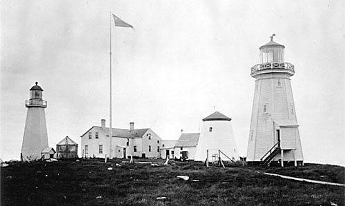
Atlas Outtake #7: Machias Seal Island
The heavens and sea of the “gray zone” are dimmed by fog and lit by one of the last standing lighthouses, its spinning lamp fully automated, its unnecessary keepers flown in by helicopter for twenty-eight day shifts—with no light-keeping to do they count migrating birds and stand in for sovereignty, fishermen on both sides ignoring the keepers and circling the no man's sea around a rock that neither Canada nor the U.S. are willing to dispute in court, both sides agreeing that purgatory is good enough and entirely appropriate for a treeless stone that might be Dante's if it weren't antipodally nowhere and exactly in-between everything that matters.

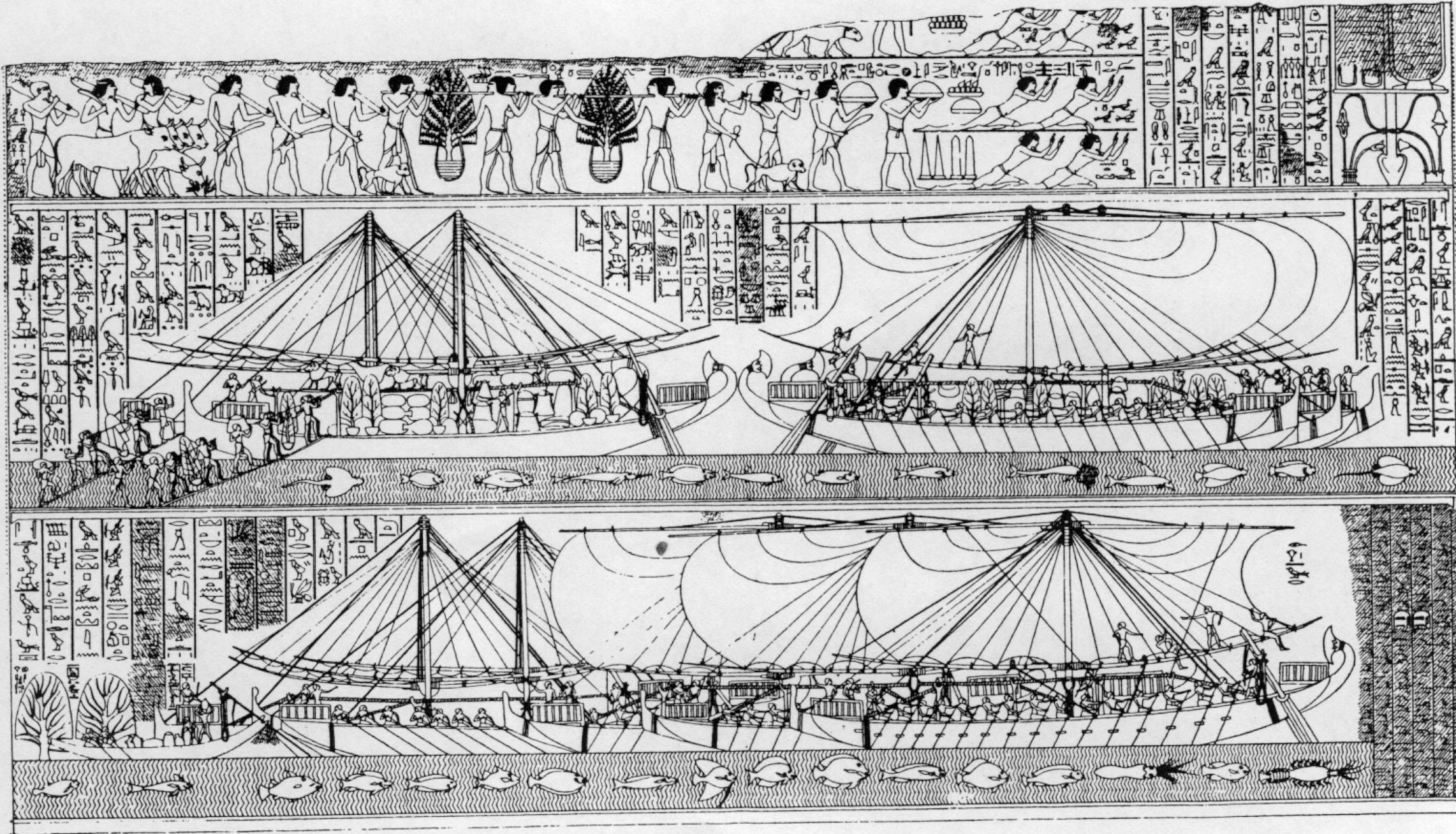
Atlas Outtake #6: Land of Punt
The pharaoh's ships traveled to the Land of Punt to barter for frankincense and myrrh. They returned with elephant tusks, mummified baboons, photos of the queen and epic tales of shipwrecks. The sailors called the Land of Punt the holy land and the place where the sun was born. It's not clear how many of the stories the Egyptians returned with were true. Traveling has a way of making liars out of people.
The Land of Punt might have been in modern-day Ethiopia, Somaliland, Somalia, or even across the Red Sea in Yemen. Egyptian maps are unreliable on this point. The one thing we are certain of is that the Egyptians were not good sailors and could not have gone far.
The Land of Punt might have been in modern-day Ethiopia, Somaliland, Somalia, or even across the Red Sea in Yemen. Egyptian maps are unreliable on this point. The one thing we are certain of is that the Egyptians were not good sailors and could not have gone far.
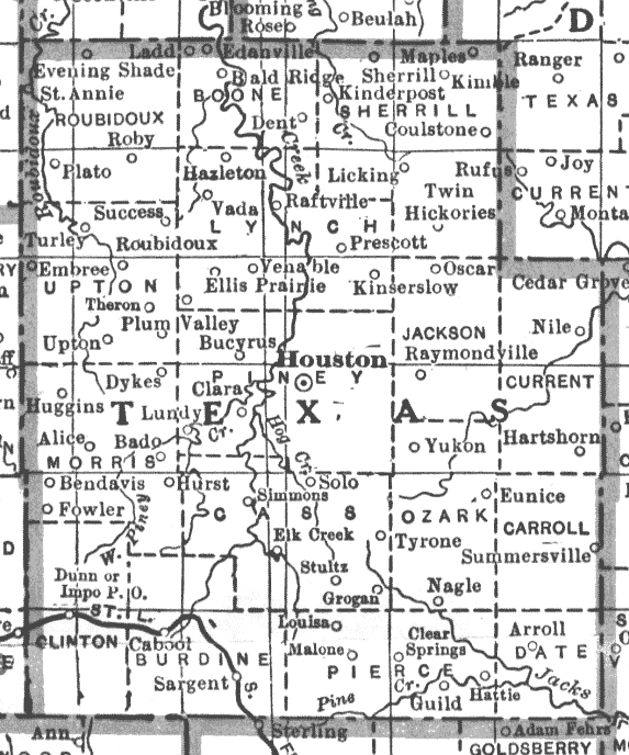
Atlas Outtake #5: Houston, Texas, Missouri / Missouri, Marshall, Texas
The
year before the Republic died the inhabitants of Ashley County smack
dab in the south center of Missouri renamed themselves in honor of
the southern nation, and named the country seat for the Republic's
sometimes capital Houston, and lived liked Texians ever after.
They
rid themselves of the natives and cleared the land of pine, and they
platted farms that left plenty of room between neighbors and declared
their loyalty to the Confederate cause just like had been done in the
Republic of Texas. And
when it came time to flee Jefferson City, the Missouri
government-in-exile went into hiding deep down south and established
its capital on South Bolivar street in Marshall, Texas, but the
citizens of Texas County went on living as Texians out in the open
and never once hid their allegiances. They
were born again in the Baptist faith and voted their consciences
Republican constant and considered themselves to be the center of
things and in fact became the center of all the nation's population,*
with the longest borders in the largest county in the state. The
county seal bore a single sun, the day's lone star, whose light they
felt revealed all that was true about the land, and as went Texas so
went Texas County and the city of Houston in Missouri.
Atlas Outtake #4: Anglo-Texan Friendship Society
1.
Graham Greene and John Sutro walk into a bar where they meet two sorority girls from Texas, you know the type: straight blonde hair, on the tall side, all around healthy-looking dames, and the plot thickens.
2.
Graham Greene and John Sutro enjoy the company of these two girls from Texas immensely, and who wouldn't? Who doesn't? I certainly do.
On the train ride home the following night Graham Greene and John Sutro refer to their chance encounter* as the birth of an Anglo-Texan Society, a phrase which amuses them intensely. They can't stop being amused by this and, being a writer, Greene writes a letter to The Times announcing the founding of a Society for the purpose of establishing ties between these two Peoples and Places. The plot gets thicker...
* An innocent one, it must be added: these were not those kind of girls, or if they were, they were at the very least the sort who do not speak of such things.
3.
Because first his letter was printed, and then steaks arrived, three whole prize winning steers-worth in fact, from the Houston Livestock Show, Texas t-bone delivered by the Air Force for the airmail express purpose of feeding the attendees of the Society's inaugural meeting, which ended up being a substantial 1500 people, after which the Society took on a life of its own, holding meetings of the educational sort, and cocktail parties, and arranging to hang plaques and engrave invitations and so on for twenty-three years longer than Graham Greene and John Sutro could have predicted.
4.
The British supported the Republic of Texas' independence to the point of guaranteeing to secure its borders if only it would stay independent, but Texas was unable to resist the Union, being—after nine independent and extremely expensive years—thoroughly broke. Still Britain hung onto the idea of Texas as long as the Texians did, and nearly longer. Now that's friendship.
5.
The building that housed the Embassy on St. James Street was once a whorehouse. The Texas Legation's final rent payments went unpaid. Long afterwards, the Embassy was memorialized by the hanging of a plaque donated by the Anglo-Texan Society to commemorate that place and, by extension, a couple of sorority girls from the heart of the once-Republic.
6.
Graham Greene and friend walk into a bar, and the rest is Texas history.

Atlas Outtake #3: County Lines
The counties of Jones, Mississippi and Winston, Alabama—similarly-sized and trapezoidally-shaped—were never officially declared the Free State of Jones and the Republic of Winston, did not secede the way their legends and tourist attractions would have it. They were only slightly less Confederate than the counties surrounding them, slightly less committed to those secessionist inclinations on account of being slightly less prosperous; on account of the pine forests that would not be cleared to make room for plantations, the soil itself limiting the size of their farms and number of farmhands. It was a numbers game, like the Twenty Negro Law that exempted one white man from military service for every twenty slaves owned, thereby exempting nearly no one from Jones and Winston. It's true that a few citizens considered seceding from the secessionists, the cost benefit analysis being simple enough that any dirt farmer could manage the math of it without the aid of a ledger. It would have been reasonable to establish unConfederate enclaves in Mississippi and Alabama, but when all was said and done it was a numbers game, and the odds were stacked against the existence of a Free State of Jones and a Republic of Winston.

Atlas Outtake #2: High & Dry
Nearly no one lives in Aksai Chin to tell stories about it, one of the highest deserts in the world, surrounded by peaks that stop the clouds from entering so the sun melts the glaciers at its borders and its lakes catch their waters briefly before releasing them downhill hoping to find someplace where water can be of more use; delimited to the north by one British civil servant and to the south by another, each with an entire nation aligned behind them but nearly no one living there to support or deny the territorial claims on either side, north of Kashmir and south of nearly nowhere.
Atlas Outtake #1: Greenland's Fault
What separates Greenland from Canada is a line that no one has been able to prove exists: it would be hard to do, the fault being beneath the Nares Strait (if there's any fault at all), where the water freezes over most of the year, and when it's not frozen then ice islands nearly half the size of Liechtenstein have been known to break off of icebergs and head south with the current for the summer. Still they manage—the Danes and Canadians—to periodically float and fly exactly halfway across the strait to Hans Island, so very in the middle of the water that both parties have been agreeing to disagree about how middling it is ever since 1973, notifying one another (the way civilized nations do) in advance of their alternating landings—sailors and ministers plant flagpoles, raise cairns, and leave a bottle of the national liquor on the uninhabited boulder, sticks and stones and alcohol being the common ingredient of all territorial disputes, even the most polite, ever since the plates first started shifting.

DISPUTED TERRITORIES is an ATLAS researched and written by ANTHONY BARILLA.
THREE YEARS in the making, DISPUTED TERRITORIES documents the author's first-hand experiences on four continents and in dozens of countries. USEFUL DATA is presented on the ORIGIN, HISTORY, and CURRENT LEGAL STATUS of various national entities, unrecognized states, submerged islands, meandering river beds, and much, much more. Special attention is given to the birth of TEXAS and death of YUGOSLAVIA. New facts are presented, calling into question the existence of a certain African nation. Cultural practices and unusual species are carefully catalogued for easy reference. A number of IMPORTANT POLITICAL MATTERS affecting the MODERN WORLD are examined.
It is the author's intent to arm you with the KNOWLEDGE YOU NEED by developing and disseminating a new kind of atlas for the discriminating consumer. DISPUTED TERRITORIES introduces an ORIGINAL SYSTEM of research, analysis, and organization, designed by the author to help you reach better-informed conclusions about the world we live in. It is the perfect gift for dedicated professionals, curious amateurs, and children of all ages.
(NOTE: DISPUTED TERRITORIES is not appropriate for children under the age of 13 due to its frank treatment of topics of a sexual and deeply emotional nature.)
Each ATLAS is handmade and comes in a handsome BOX to protect it from WEAR AND TEAR. What's more, atlases are produced in limited editions of twenty or less, meaning that each one is a unique WORK OF ART.
At the author's insistence, DISPUTED TERRITORIES will not be sold online or in stores. Instead, each series of up to twenty atlases will be made available on a case-by-case basis to interested parties along with a BRIEF and ILLUMINATING LECTURE BY THE AUTHOR, who will provide useful and personalized recommendations on the PROPER USE AND ENJOYMENT of the atlases. And now, YOU can have the pleasure of hosting one of these STIMULATING AND EDUCATIONAL EVENINGS, thereby enriching your social circle and earning the gratitude of your friends and colleagues. Individuals interested in hosting a reading in their home, lodge, local civic center, etc. should contact the author immediately. Presentations will begin in the late spring and early summer of 2015.
DO NOT WAIT TOO LONG to take advantage of this opportunity: DISPUTED TERRITORIES addresses problems affecting us today, using the methods and logic of a WELL-TRAINED ARTIST. Your well-being as an ARTS CONSUMER and CITIZEN OF THE WORLD may well be strongly impacted by the contents of this new, one-of-a-kind reference book.
* * *
This project was made possible with support from the Kimmel Harding Nelson Center for the Arts and funding by the Puffin Foundation.